
Saturday 9/26/2020 we took a well-deserved break from Rocky Mountain National Park and instead traveled the two hours to White River National Forest to bag the highest named lake in the continental United States. – Pacific Tarn (13,420 ft). The lake lies at the base of 13er Pacific Peak (13,957 ft); the hike to Pacific Tarn is akin to a 13er or 14er summit hike.
To date, the most strenuous hike we’ve completed was Longs Peak. However, the gully leading up to Pacific Tarn was more dicey than anything we’ve seen on Longs.
Video of our Hike to Pacific Tarn
Hiking to the Highest Named Lake in the United States
Pacific Tarn can be accessed from McCullough Gulch Trailhead, two miles past the trailhead for Quandary Peak just outside of Breckenridge. At 6AM, the crowds attempting a summit push for Quandary were in full swing, and it was a task navigating parked cars along the gravel road in the dark. Soon the vehicular traffic waned, and we bumped along route 851 until reaching a pull-off just before the gated area. While the road is accessible to 2WD vehicles with low clearance, I would have much preferred something more suitable.
The road is blocked to the trailhead itself and a 0.7 mile walk one way is required before turning off route 851. While the road is flat, as soon as the turn is made onto the trail, the elevation gain ramps up. It was immediately clear to us that this hike is heavily trafficked; multiple offshoots coupled with headlamp hiking disoriented us at times. There are signposts marked “trail” with arrows but we still referenced our maps and GPS.
White Falls on McCullough Gulch Trail

As the sun began to rise, we arrived at White Falls 1.8 miles into our expedition. White Falls (11,600 ft) is a compilation of smaller cascades joining together to form a long strip of flowing water.

In my opinion, the vantage point from the base of the falls gives the best overall view. Vibrant orange leaves on surrounding bushes created a quintessential autumn landscape. Across the river stands the silhouette of Quandary Peak, which offered great views as we made our way up.
Lower Lake on McCullough Gulch Trail

Tree coverage shielded us from the wind until we reached Lower Lake and got a taste of its intensity. The peculiar shaped Lower Lake, 2.2 miles from our vehicle with 900 feet of elevation gain makes for a great day hike (this was further evidenced by our return trip). Quandary Peak (14,265 ft) is an unavoidable presence on the left bank, while Atlantic Peak (13,835 ft) and Fletcher Mountain (13,958 ft) can be seen in the background.
After taking pictures of Lower Lake, we followed the trail to the right and continued our ascent. At the opposite end of Lower Lake, there are a few cascades that we stopped to admire.
Here, the trail works its way through dense shrubbery and over rocks – not a bushwhack but not particularly pleasant. The view of Lower Lake from above brought us validation for our efforts.
Between Lower Lake and ‘Middle Lake’ resides 1 mile of distance and 600 feet of elevation gain. The views on this stretch are beautiful, with Atlantic Peak looming ever closer and Quandary Peak hugging in on the left.

Again the heavy winds greeted us at Middle Lake, where we diverged from the Quandary Peak Trail and veered right. This upper lake had a thin tract of land extending into the water, though we didn’t get the chance to admire this one from above en route to Pacific Tarn.
White Falls and the two lakes are the main attractions at McCullough Gulch trail. There is dispersed camping throughout this beautiful area boasting amazing views. Beyond the second lake the trail ends and the fun begins…
Ascending up the Gully
Here the difficult hiking began, starting with an off-trail jaunt over grassy areas followed by boulder hopping. Through the boulders we began to encounter dispersed cairns but we remained wary, as we didn’t want to end up on the slopes of Atlantic Peak. We had to boulder hop for quite some time before finding a suitable gully in which to ascend, and even this route put our mental and physical strength to the test.

The dispersed cairns and faint trail through the boulders abruptly stop at 4.2 miles, where the elevation is at its most punishing. At times we were ascending slopes at a 40-50% grade, while surrounding rocks, scree and talus were wildly unreliable. We used extreme caution with our footfalls, as a wrong step could send dangerous rocks sliding down the slopes. We had to hunker down against strong wind gusts blowing down the slopes and keep an eye on the map. The unyielding terrain and class 3 rock maneuvers made the remaining 0.3 miles to Pacific Tarn feel much longer. The unnamed ponds below our position here are wonderful, though we hardly gave them much consideration.
Despite our close adherence to maps and GPS, we found ourselves off-route at the top of the gully. To correct ourselves we walked north through a grassy patch to another boulder field – the final push separating us from Pacific Tarn. The elevation gain had eased considerably, but there is one false lake ‘summit’ to navigate first before reaching the banks. Climbing up some solid boulders felt like a cake walk compared to what we had just been through.
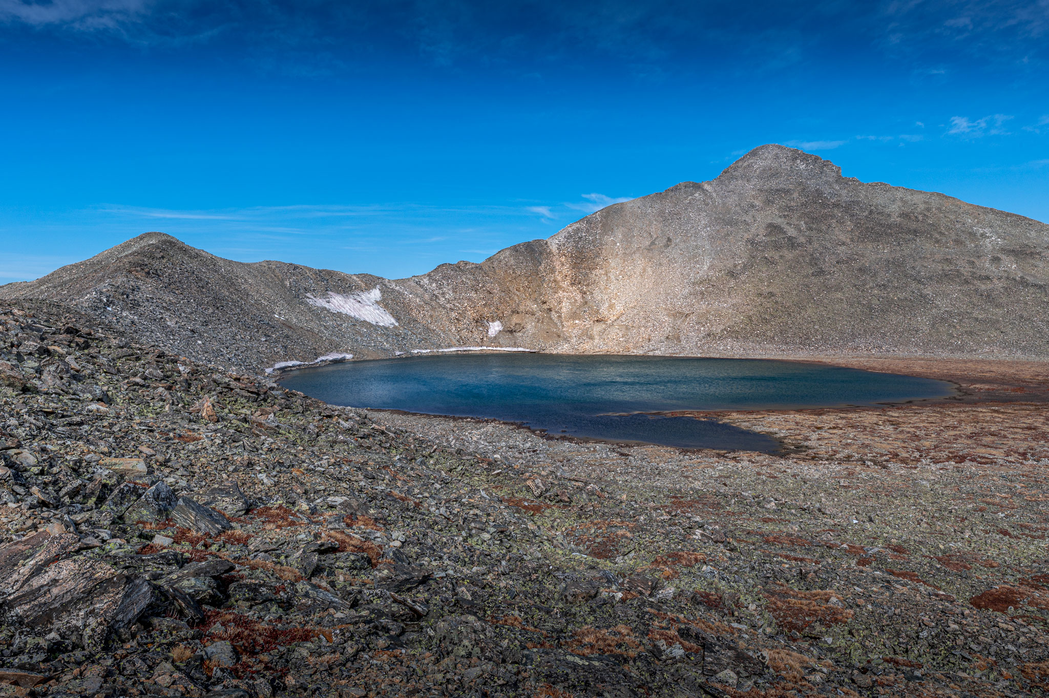
Pacific Tarn – Highest Named Lake in the United States

Pacific Tarn at last: 4.8 miles one way and 2,625 feet of elevation gain. The lake is deep blue in color and quite circular, save for a small tail toward the east indicating the drainage. The surrounding shore is covered in small boulders and rocks that dip into the tarn.

Pacific Tarn boasts excellent 360 views; Pacific Peak dominates the scene, Atlantic Peak hides just behind a bump along the ridge, and the summit of Crystal Peak can be seen to the northeast. The warm summer months did nothing to deter snowfields clinging to the edges of the lake.

At the highest elevation lake in the United States, we decided to experiment with the GoPro 7 and the buoyant GoPro mount. Dave began a recording and tossed the camera into the lake. Ripples caused by the wind eventually returned GoPro to owner (thank god) and the underwater footage in the shallow portions was clear; we were not so lucky where the depth was greater due to moving water. I propose in the future we get a string to pull the GoPro back (this one happens to be ‘my’ camera). We had the lake to ourselves, but there were four climbers atop Pacific Peak and we could hear their voices echoing down.

Descending down from Pacific Tarn
The dreaded descent through the gully could not be avoided, and after a half hour at Pacific Tarn we were ready to face this battle. The loose rock and talus had not eased in difficulty; both a mental and physical challenge. At one point, a rock the size of a watermelon, dislodged by a heavy wind, came barreling down and missed Dave by a few feet. A rock of that magnitude could have left considerable injury. We vowed henceforth to always pack our helmets when off-trail hiking was in the forecast.
We were overjoyed to reach the bottom of the gully, much preferring the boulder hopping to the arduous descent behind us. The wind had relented some, and soon we were back at Middle Lake. Here we began to see an increasing number of hikers taking advantage of a colorful Colorado fall day. Between Middle and Lower Lake we passed several groups, and even more below Lower Lake.
The parking at McCullough Gulch trailhead is limited, and visitors resort to parallel parking along the dirt road on both sides. When we arrived back on route 851, cars were crammed on either side and we felt lucky to have an actual parking spot. Due to the popularity of this hike, the earlier the better. The 9.6 miles round trip to Pacific Tarn was a strenuous ordeal, but the opportunity to stand at the highest named lake in the United States more than compensates.
Love watching your videos especially the ones in rmnp. I just started hiking 3 yrs ago and the videos kinda give me an idea of the trails I want to do. Thankyou.
Thanks for checking them out Tom, glad you enjoy them!