
Hiked over 17 miles, 3,700 feet of elevation gain, 6 lakes, 1 waterfall, in the northwest section of Wild Basin in Rocky Mountain National Park, Allenspark, Colorado. Main attractions visited were Castle Lakes, Lion Lake #1, Trio Falls, Lion Lake #2, Snowbank Lake, Castle Lake and Twin Lakes.
Video of our Day Hike to Lion Lakes, Snowbank Lake and more
Labor Day weekend signified our return to the Wild Basin region of Rocky Mountain National Park and our longest hike in the park yet: a 17 mile trek to visit six lakes. The Wild Basin road was closed for repairs the week previous, and the conditions of the bumpy one way dirt thoroughfare was much improved. At 5:30AM the parking lot was beginning to buzz with activity, we quickly began our recordings on AllTrails and got moving.

Campsite Shortcut Trail to Lion Lakes
The first mile and a half closely follows North St. Vrain Creek, although we could only hear the rushing water through the darkness. To save mileage, we turned right onto the Thunder Lake Trail that passes several campsites, forgoing popular waterfall destinations Calypso Cascades and Ouzel Falls.
This trail is reminiscent of the Fire Trail in the Glacier Gorge area; not a particularly exciting ramble through the forest but useful when trying to save on time and distance. We packed the headlamps away at a scenic overlook of Copeland mountain 2.5 miles in; despite the lingering haze, the day was shaping up to be ideal – bluebird skies, minimal winds and a pleasant temperature.
A trail junction with the Wild Basin Trail (leading to Ouzel Falls, Ouzel Lake and Bluebird Lake) indicates the three mile mark from the trailhead, a slight right kept us on route for Lion Lake 1. An additional mile of hiking separates this trail junction with the turn-off for Thunder Lake. The elevation begins in earnest on the Lion Lake Trail, a total of 800 ft in just over 2 miles.
On the Lion Lake Trail the morning lighting was superb and we stopped to take some pictures. Though the sun was rising, a waning gibbous in the sky opposite lingered well into the morning. In a stroke of luck, we were close to Castle Lakes, 5.1 miles from the trailhead.
Castle Lakes via Lion Lake Trail

These small ponds make a figure eight shape and can be seen from the trail on the right-hand side. The soil circling Castle Lakes has a sponge-like consistency but our feet remained dry. Around the perimeter there were moose tracks everywhere, though there were no moose sightings for us today (typical).

With Castle Lakes in the books, we continued on to Lion Lake No. 1, three quarters of a mile from our current location. Presently, we had only encountered two other hiking pairs and the solitude was welcome.
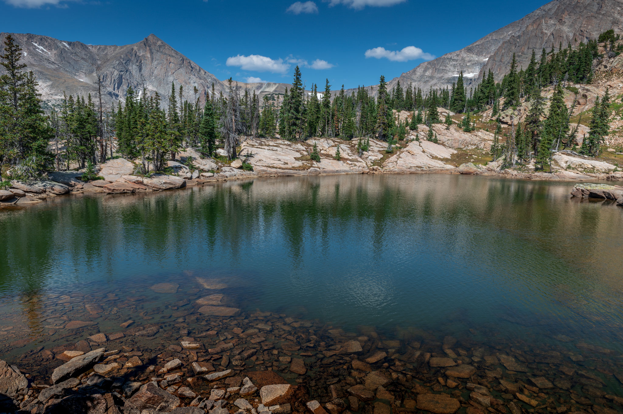
Lion Lake #1

After winding through switchbacks the tail of Lion Lake No. 1 became visible to the left. We halted once more to capture the splendor of the Lion Lake drainage. Moving toward the brunt of the lake, Dave startled some white-tailed ptarmigans nesting in the grass.

Lion Lake No. 1 is the first of three alpine tarns stemming from a tributary of North St. Vrain Creek. Due to the lateness of wildflower season, the grassy tundra surrounding the lake wasn’t in bloom, but the surrounding peaks made up for the lack of flower décor. The triangle shaped peak of Mount Alice stretches over the lake, while Chiefs Head Peak towers over the far end of the lake.

At this point the trail earns an unmaintained title, but this designation was not discouraging in the slightest; the only complications we had were self-inflicted. The trail hugs the creek up to Lion Lake No. 2 until just before reaching the banks where it veers left to avoid steep rocks around Trio Falls. Make shoulder checks during this stretch, as the view above of Lion Lake 1 and the adjoining creek is beautiful, especially with sunlight shimmering on the water.
The halfway point between the Lions is marked by Trio Falls, a triple cascade that falls over a rocky shelf. White streaks on the rock told tales of past high water levels, but in early September there is not much snow-melt to speak of, causing some waterfalls to lose ferocity. The trail can be seen meandering around the falls, but we opted to test out some class 3 climbing moves right up the falls. While the climbing was an exciting challenge, our “shortcut” backfired and we found ourselves in a short bushwhack through Krummholz and shrubbery. Nevertheless, we arrived at Lion Lake 2, 7 miles from the Wild Basin Trailhead.
Lion Lake #2

A cascade is discernible on the opposite bank, while Mount Alice and Chiefs Head Peak continue to dominate the skyline. The camera, tripod and GoPros were promptly brought to the shore for more footage. The boulders surrounding Lion Lake No. 2 had an odd coloring, almost a red/black combination that contrasts the familiar light grey.

Our deviation from the traditional path did not bode well for the rest of our trip to Snowbank Lake; we found ourselves bouldering around the right side of Lion Lake No. 2. While this alternate route was more difficult and added time to our hike, it was pleasing to see Lion Lake #2 from all different angles.
Snowbank Lake

Snowbank Lake, true to its name, had snow clinging on the waters’ edge. Unlike other less-traveled lakes in the park, we encountered 5 or 6 other hikers enjoying the morning views. Wind on the water created wave-like patterns, though the wind didn’t bother us much.

A long line of boulders dissects Snowbank Lake, and we hopped out as far as we could without wetting our feet. The one way distance to Snowbank Lake was 7.5 miles with 3,000 feet of elevation gain. The rugged profiles of Mount Alice and Chiefs Head Peak are thrown into sharper relief here than the lower elevation lakes, making Snowbank Lake an advisable target.

A few moments were spent at the lake before turning our attention back to Lion Lakes and our future destination, Castle Lake, lying 0.3 miles southeast of Lion Lake No. 1. The standard route was much easier on our bodies and minds on the descent, and soon we were below Lion Lake No. 2. We stopped several times along the creek to take pictures of small waterfalls we overlooked earlier. Again we took an alternate route to stay closer to falling water and rejoined the trail at the mouth of Lion Lake No. 1.
Castle Lake – off trail

There is no indication of a trail to Castle Lake, the best directional advice I can give is the following: descend past Lion Lake 1 and look for a very large boulder on the left. Turn left into the forest and bushwhack (though this area is fairly clear) to a rock wall. Bear right to an opening in the wall that makes for easy climbing. From here we skirted a small dried-up pond and a few steps later Castle Lake loomed into view.

Castle Lake is a doughnut shaped body of water with a thin strip of rock serving as the ‘drawbridge’ and a tree covered boulder symbolizing the ‘castle.’ Due to its proximity to Lion Lake 1, Castle Lake is often overlooked but the 0.3 miles is a worthwhile trip. Excellent views of Mount Alice, Tanima Peak and Pilot Mountain soar over the stumpy trees of Castle Lake. In order to avoid confusion with the smaller Castle Lakes, I would propose this lake be renamed Fortune Lake, as it resembles a fortune cookie.
After reuniting with the Lion Lake Trail and passing the intersection for Thunder Lake Trail, we discussed the best possible route to Twin Lakes, two mis-matched lakes 300 vertical feet above us. Any trail to Twin Lakes did not reveal itself to us on our maps, nor had we read anything of significance in our research – we were on our own.
Twin Lakes – off trail

Near the Siskin Campsite, we turned off the Thunder Lake trail and headed northeast up a slope that became increasingly steeper. Navigation around fallen trees and vegetation was necessary, but with the help of our maps we were able to stay on course.
Areas of slippery rocks also hindered our upward progression. While the off-trail hike was a mere third of a mile, the grueling uphill and the 12.5 miles we hiked prior had our legs feeling rubbery. We were rejuvenated by the sight of Lower Twin Lake and by its unexpected beauty. The lake was rimmed with lily pads and was surprising large.

From Lower Twin Lake we were treated with a whole new perspective of the Wild Basin area; Copeland Mountain rules the skyline and is complemented by the unique spire of Eagles Beak. We decided to forgo the smaller, crescent-shaped Twin Lake as there was considerable bushwhacking involved to pursue it.
We were invigorated upon reaching the Thunder Lake Trail once more, despite our 13 miles of hiking. It was a curious reversal today: usually we encounter other hikers on our return trip, but today we didn’t see a single soul until reuniting with the Wild Basin Trail.
The sky was beginning to turn a light shade of grey, but I think this can be attributed to nearby fires instead of weather issues. The three miles remaining after our excursion to Twin Lakes seemed to fly by and soon we were back in the parking lot. Just under 17 miles of total distance and 3,640 feet of elevation rounded out our statistics for the day. Another section of the Wild Basin completed, and still we’re eager for more.
Next up: A trip to the Thunder Lake area, or to the lakes perched above Bluebird Lake – stay tuned to find out!
Leave a Reply
You must be logged in to post a comment.