
Longs Peak Keyhole Route
Longs Peak (14,259′), this hike has been on our bucket list for awhile. We had done our homework on the Longs Peak Keyhole route. Watched every video and read descriptions on 14ers.com and other blog posts. Emily and I were as prepared as could be.
08/09/20 – Getting barely any sleep, we departed from Denver at 11:30pm and arrived at Longs Peak trailhead at 1:10am. There was still about 8 parking spots left, but by the time we hit the Longs Peak trail we saw 5 cars pull in.
The Longs Peak Keyhole Route we took started from the Longs Peak trailhead (9,405 ft). All distances and elevation is approximate, and what was recorded on our GPS. Your mileage may not be the same as ours was.
Longs Peak Keyhole Route Video in 4K
I brought my 2 GoPros and Nikon D780, 24mm 1.8 lens and tripod so that I could make the best video out there on the Longs Peak Keyhole Route. Highly recommend watching this if you are planning on attempting Longs Peak.
The beginning is a hike on a well marked trail of switchbacks through a forest, until you get above treeline. Follow the cairns until you reach the trailhead junction for the Longs Peak Trail and Chasm Lake Trail. 3.4 miles in at 11,536 ft.

At 6.0 miles and 12,717 ft we arrived at the Boulderfield. Navigating through the dark wasn’t that difficult for some reason, just payed close attention to the cairns. Once you start getting close to the Keyhole, some scrambling is required to get to the top.
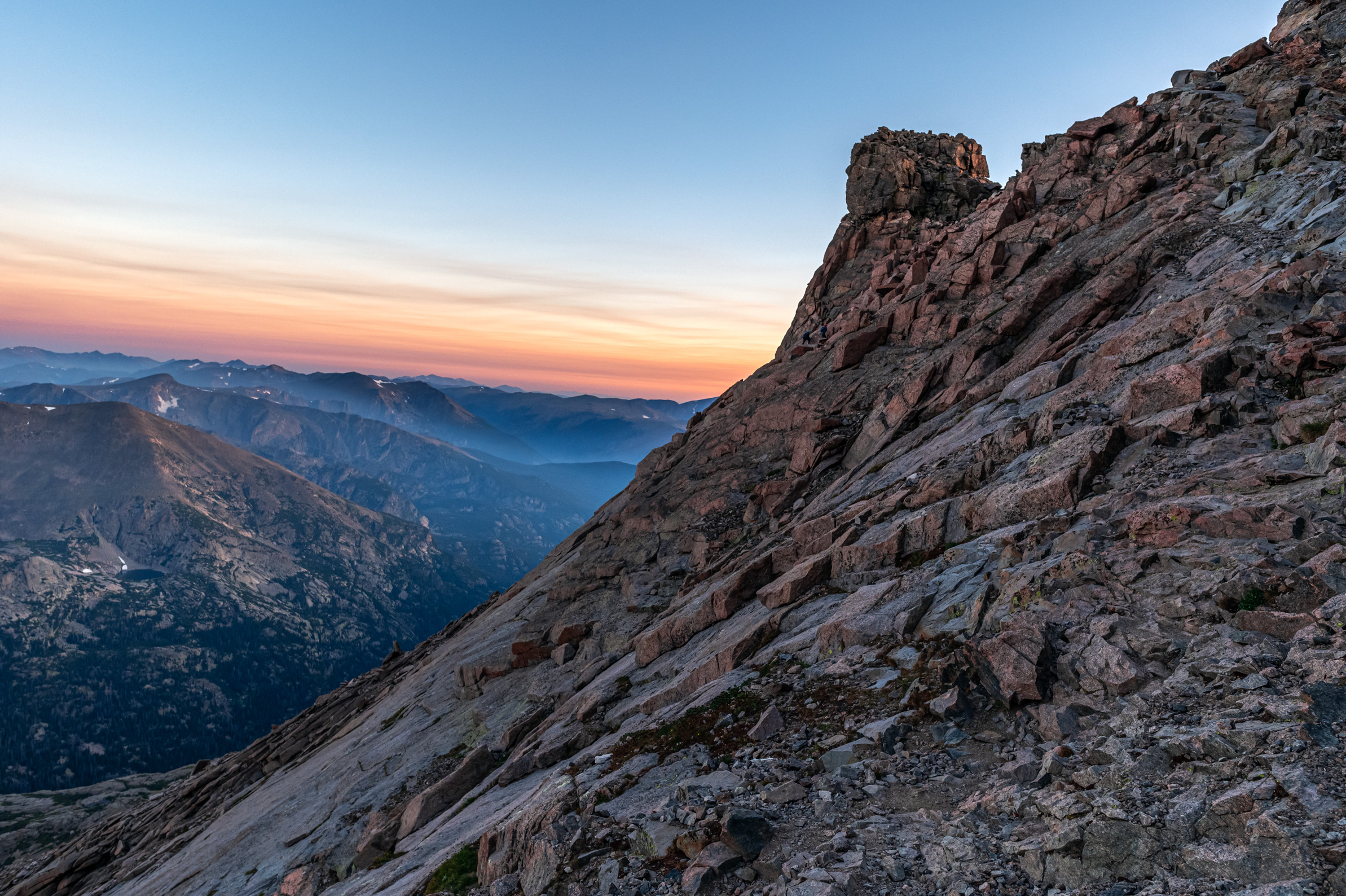
The Keyhole
The plan was to be at the top of the Keyhole for sunrise, so I could get some photos. We overshot the time and arrived about an hour before sunrise. We hung out in the Agnes Vaille Shelter for about 30 minutes. Took some photographs of the headlamps marching through the Boulderfield then hopped on the other side of the windy, cold Keyhole.

Longs Peak Ledges
Watching the sunrise over the Glacier Gorge once we got through the Keyhole was a pretty magical experience. Slow pace, as I stopped constantly to try and get as many photographs as I could. Communication is key on this route with others that are around you. Since I was going slow and stopping constantly I offered several people to pass me up. As a photographer, the sunrise views on the Ledges was the prettiest part of the entire hike.

However, this is where the hike ends and the Class 3 climb begins. Although it’s only 1 mile from the Keyhole to the summit, it’s a grueling series of named sections that will test you physically and mentally. The drop-offs here can be deadly. Attempting the Keyhole route in bad weather conditions, such as rain, wind and snow, should only be attempted by experienced climbers. The weather we had on this day was perfect.

The Ledges seem like you are going up and down a lot. Make sure to follow the painted bulls eyes here as you do not want to get off route. After navigating though the Ledges for .4 miles we arrived at the Trough. 7 miles in at 13,365 ft.
The Trough Longs Peak
This probably one of the hardest parts of the Longs Peak Keyhole Route. Over 600 ft of elevation gain in just under .4 miles. Just as with the entire Keyhole Route, keep an eye out for the painted bull eyes. The granite rock here can also be extremely slick do to being polished down over the years.
At the top of the Trough there is a crux move that requires climbing up about 15 ft using both hands and foot holds. There are also less technical options by going up to the right or left of the crux move which I saw several people doing.

For me climbing down the crux move on the Trough was a lot tougher than going up it. Although Emily handled going up like a champ she opted to go down the side on the way back. This part of the climb is often where the traffic jams are as well. So keep in mind the other ways around this move.

Once at the top of the Trough the views change as you are on the other side of the mountain. The ridge that connects Longs Peak and Pagoda Mountain is where you will begin to navigate through the Narrows.
The Narrows Longs Peak
We are now 7 miles in at 13,930 ft. The Narrows is where the GoPro footage looks scary. The exposure is high. But I can assure you, that it is not as scary as the GoPro and wide angle footage makes it look. If the rock is iced over or wet, things change and the exposure gets more real. This is why it’s recommended to do this during late summer and early to try and avoid ice and rain.

The Narrows is only about .1 miles. With good conditions you can pass people with no problem, as I show you in my video of our Longs Peak climb. I know that everyone handles exposure on a mountain differently though. Just keep in mind it’s not that long of a section and seemed like we were at the Homestretch in no time.

The Homestretch
At 7.4 miles in and 13,950 ft we arrived at the Homestretch. About 300 ft of elevation gain in .2 miles. The Homestretch can be difficult for many reasons. The main one is the granite rock is extremely slick. Going up isn’t as bad as coming down in my opinion. Just take it slow, follow the big crack, communicate with other climbers around you.

Summit of Longs Peak
We made it to the summit of Longs Peak (14,259 ft) at 7am. This was my 7th Colorado 14er and definitely the longest that I’ve done to date. Still on an empty stomach, it was time to celebrate with none other than a Longs Lager from 14er Brewing company.

The conditions were perfect and there was no wind on this day. Amazing views in every direction. I took a bunch of pictures, and clocked in at .5 miles to circle the summit of Longs Peak.


We spent about 30 minutes on the summit soaking in all the amazing views and our accomplishment. Our journey was far from over though. Descending the Homestretch and the rest of the Longs Peak Keyhole Route is where the most injuries happen. Just to be on the safe side we ate a couple of energy bars before making our way down. Which is a rarity because we never eat when we are on day hikes.

With the camera gear now stashed in my bag we were ready to descend. Going down the Homestretch was pretty sketchy but not horrible. The worst part for us was going back through the Boulderfield. Seemed like it was easier in the dark. Took the Jim Groves trail back to shave off about 1/2 mile of hiking distance. Completed Longs Peak Keyhole Route via Longs Peak trailhead in just under 12 hours with plenty of stops on the way up.
Tips for a Successful Summit via Longs Peak Keyhole Route
- Longs Peak should only be attempted by experienced hikers. Not a good ‘1st 14er’.
- Best attempted mid June through September. Winter conditions can happen earlier or later in some years. Crampons, Ice axes and mountaineering skills required in winter conditions.
- Get to the trailhead no later than 2am in the summer. Unless you don’t mind getting ticketed. There were several parking tickets on cars on the way driving back down.
- Parking at the Glacier Gorge trailhead in RMNP is another option. Although this will add about 1 mile and 500 ft of elevation gain to the entire trip.
- Longs Peak Keyhole Route is a long, difficult Class 3 climb. It’s not a hike. Expect 15 miles with 5,100 ft of elevation gain.
- Helmets recommended in the Trough section and beyond. About 80% of the climbers didn’t have head protection when we were there.
- There’s no bathrooms once through the Keyhole or water source. Bring plenty of water and use the solar restroom in the Boulderfield
- Longs Peak Campground is a first come first serve campsite that is currently closed due to COVID-19. Check here for updates. Camping is by reservation only at the Boulderfield, Goblins Forest, and Battle Mountain Group sites. More info here
- You will be exposed to the elements most of the route. Bring sunscreen, rain gear, and plenty of water. I did it with 2.4 Liters of water but was running low at the end.
- Bring a water filter and fill up right before Boulderfield to save a little weight.
- If the weather looks bad at the Keyhole, think long and hard on whether you should continue or not. The Agnes Vaille Shelter provides wind and rain protection. It will not protect you from lightning.
- Weather on 14ers is unpredictable. Don’t trust the forecast. In the summer afternoon thunder storms are common and you will want to be well off the summit before they start rolling in.
Have you completed the Longs Peak Keyhole Route before? Do you plan on attempting the Keyhole route in the future? Please leave a comment with your experience or questions, and we will be sure to reply as soon as possible!
Leave a Reply
You must be logged in to post a comment.