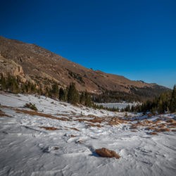
Wild Basin is in the southeast part of Rocky Mountain National Park. Wild Basin Entrance Station is located between Meeker and Allenspark, Colorado, off Colorado State Highway 7. About 18 miles south of Estes Park, keep an eye out for the sign.
The Beautiful Wild Basin
Trailheads and Hiking Trails at Wild Basin
Wild Basin Entrance Station Coordinates: 40.2196, -105.5344 | Elevation: 8,314 ft
Wild Basin has 3 main trailheads. The 3 trailheads have solar toilets. A 4th parking area, usually becomes a main trailhead in the winter, known as the Wild Basin Winter Trailhead, about 1 mile past the entrance station. There are many other places to pull off and have a picnic, or enjoy some scenery by North St. Vrain Creek or Copeland Lake.
Sandbeach Lake Trailhead: Elevation 8,314 ft

Attractions with maintained trails: Sandbeach Lake (4.2 Miles) *1 way
Off trail Hikes to Scenic Destinations: Mt. Orton, Keplinger Lake, Chiefs Head Peak, Pagoda Mountain, Longs Peak via Keplinger Couloir
Wilderness Campsites near Sandbeach Lake – Hole-in-the-wall, Campers Creek, Beaver Mill, Hunters Creek and Sandbeach Lake campsite.
Finch Lake Trailhead: Elevation 8,475 ft

*All mileage listed below is 1-way
Attractions with maintained trails: Finch Lake (4.5 miles) and Pear Lake (6.5 miles)
Off trail Hikes to Scenic Destinations: Hutcheson Lakes, Cony Lake, Ogalalla Peak, Copeland Mountain
Wilderness Campsites in the Finch Lake area (2) Finch Lake, Pear Lake
For a full report and video on camping at Pear Lake check out our blog post Camping in Rocky Mountain National Park.
Wild Basin Trailhead: Elevation 8,500 ft

Located 2.1 Miles from the Wild Basin Entrance Station, this trailhead offers the most hiking options. It also has a Ranger Station. Drive (or walk) down Co Hwy 115 which is a gravel road. Parts of the road are very narrow and many places there is only room for one vehicle to pass.
During winter conditions you may need to park at the Wild Basin Winter Trailhead which will add 2.2 Miles Round-trip to your hike. Wild Basin Winter Trailhead to Wild Basin Trailhead = 1.1 Miles one way
*All mileage listed below is 1-way
Attractions with maintained trails: Copeland Falls (.3 miles), Calypso Cascades (1.8 miles), Ouzel Falls 2.7 miles, Ouzel Lake (5 miles), Bluebird Lake (6.3 miles) Thunder Lake (6.6 miles) Lion Lake Number 1 (7 miles)
Off trail Hikes to Scenic Destinations: Lion Lake Number 2, Snowbank Lake, Thunder Falls, Falcon Lake, Lake of Many Winds, Twin Lakes, Castle Lake, Castle Lakes, Box Lake, Indigo Pond, Frigid Lake, Moomaw Glacier, Isolation Lake, Pipit Lake, Lark Pond, Junco Lake, Copeland Mountain, Ouzel Peak, Mahana Peak, Mount Alice, Tanima Peak, Pilot Mountain, Eagles Beak, Mertensia Falls, Fan Falls.
Wilderness Campsites in the Wild Basin Trailhead area (7) – Tahosa, Aspen Knoll, Siskin, North St Vrain, Thunder Lake, Ouzel Lake, upper Ouzel Lake

