
The East Side of Rocky Mountain National Park has much to offer; proximity to Denver and a plethora of gorgeous day hikes. This long weekend, we opted for the longer drive to Grand Lake – the home of the West Side of the park. Prior to check in at the Timberline Inn, we snuck in a 6 mile hike at Berthoud Pass to Mount Flora (13,164 ft), explored downtown Grand Lake, and sampled the local cuisine at White Buffalo Pizza. There was just enough time to unload our gear and hop back in the car to reach Lake Irene (10,680 ft) for sunset, a 17 mile drive from Grand Lake along Trail Ridge Road.
Video of our Hike to on the East Inlet Trail
Hiking the East Inlet Trail
5:15AM on October 11th, we took our first steps along East Inlet Trail, entirely new ground for us. Six destinations were on the list: Lone Pine Lake, Lake Verna, Spirit Lake, Fourth Lake, Fifth Lake and Adams Falls. The North Inlet and East Inlet Trails are very close to Grand Lake, we certainly didn’t miss the long drives in the dark from Estes Park to trailhead in Rocky Mountain National Park. Dave was also testing out a streamlined system today. A new camera backpack allowed for easier access to photography gear and more room for essentials. He also carried three GoPros and backup batteries for videography.
East Inlet Trail features a gradual elevation gain to start, with 200 vertical feet in 2 miles. It was impossible to see Adams Falls and East Meadow with headlamps – we would return at the end of our trip. After passing Lower East Inlet Campsite, the trail spikes in elevation gain and navigates through several switchbacks and stone steps. Headlamps were stowed at 4.5 miles in. We stopped at a bridge crossing East Inlet Creek and Dave unpacked the camera to take water compositions and other landscape photography. Another 1.5 miles stood between us and Lone Pine Lake. We were surprised by the number of campsites along this trail. Wild Basin aside, wilderness campsites are rarely encountered on the east side.
Lone Pine Lake

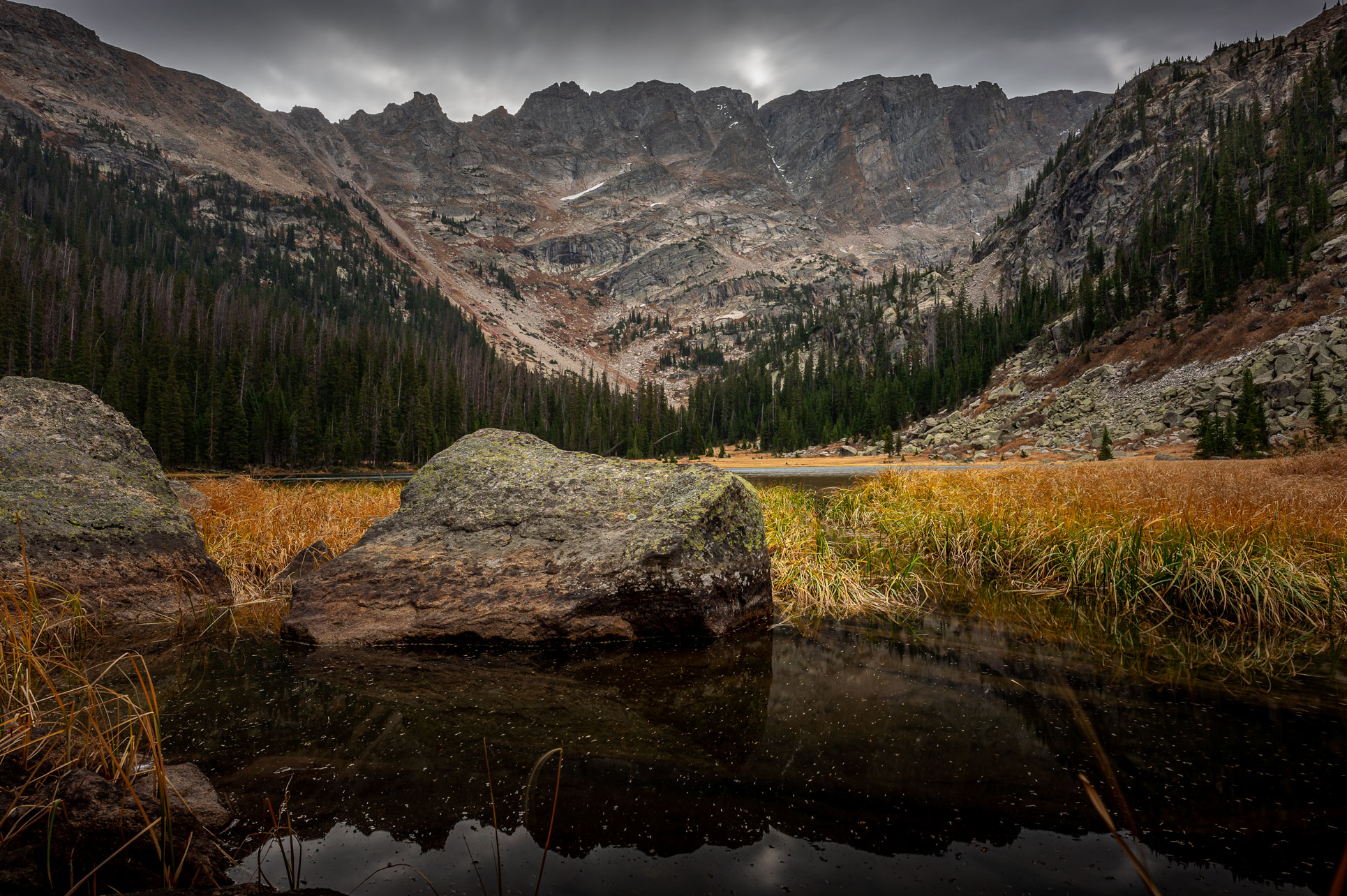
After a lengthy hike in the dark, Lone Pine Lake was a welcome sight. Lone Pine Lake (9,900 ft) is the lowest elevation in a string of five lakes beaded along East Inlet Creek, the product of runoff from Isolation Peak. The ‘Lone Pine’ designation is no longer relevant. Several trees have taken root on the island for which the lake is named, though this did not deter the beauty. Mount Craig, surrounded by a forest of pines encircles Lone Pine Lake.
A maintained trail heads along the right bank of Lone Pine Lake for 0.2 miles before traveling through switchbacks and crossing three sturdy bridges. The trail then adheres to the creek closely, and two unnamed ponds can be seen below. After passing Lone Pine Lake, 1.2 miles and 300 feet of elevation are required to attain Lake Verna, 7 miles from the trailhead.
Lake Verna

The noticeable length of Lake Verna (10,180 ft) distinguishes it from other lakes in the park. Hiking along Lake Verna brought to mind Eagle Lake in Wild Basin and The Loch Lake in Loch Vale as both take seemingly forever to circumnavigate. The hike to the opposite end of Lake Verna took 0.8 miles alone (Eagle Lake is a modest 0.3 miles in comparison). Prolonged as it was, the views around Lake Verna were incredible, especially the unofficially named tower ‘Aiguille de Fleur’ (translation: Flower Needle). In addition, sandy shores and beach-like waves made Lake Verna truly memorable. Here we encountered company – four hikers who had camped at Lake Verna the previous night.
The official trail tapers at the far end of Lake Verna, but an unmaintained trail persists to the upper lakes. Research indicated that several large trees had fallen over the path, ramping up the difficultly level but this did nothing to deter us.
A diminished trail wends through 0.3 miles of heavy forest. This portion must have been maintained at one point, as older fallen trees were cut and removed, but the trail seems to have been neglected for some time. Were it not for the trees, the trail would be straightforward, but dozens of fallen trees in close quarters would set us off-course.
Spirit Lake

To make up for the abundance of felled trees, the elevation gain was negligent, and soon we were at our third destination: Spirit Lake (10,300 ft). ‘Aiguille de Fleur’ continues to be a commanding presence to the south, while a grassy meadow painted gold for the Fall season grows on the east side. The trail continues along the north side of Spirit Lake, and we continued our battle with downed trees until passing Fourth Lake.
Fourth Lake

The immediacy of the first four lakes is astounding, another 0.4 miles from Spirit Lake and we were on the banks of Fourth Lake (10,380 ft). Banks of Fourth Lake are dominated by golden meadows, and behind we could see the rocky incline of Boulder Grand Pass. Continuing via East Inlet Trail (unmaintained), we were glad to emerge from the forest and leave the fallen trees behind. A close adherence to East Inlet Creek for 0.8 miles leads to the final lake, Fifth Lake.
After passing Fourth Lake there are two trails; one is the Fifth Lake Trail marked with dispersed cairns, the other is the trail leading over Boulder Grand Pass. We lacked diligence checking the map and ended up on the Boulder Grand Pass Trail; we had to correct ourselves with a short boulder-hop. The Fifth Lake turnoff is marked with a small cairn on the right that is easy to miss – we try not to put much trust in cairns, but on this hike, the cairns are accurate.
Once reunited with Fifth Lake Trail, the elevation gain was brutal. Stunted trees grew on the steep slopes, and reminiscent of our hikes to Loomis Lake and Tourmaline Lake, it was 500 feet of elevation gain in 0.5 miles. We paralleled the Fifth Lake drainage, and finally our fifth destination came into perspective.
Fifth Lake

Fifth Lake (10,380 ft) was not yet frozen, but some frozen cascades garnished the rock wall opposite. The grassy shoreline on which we stood was a severe contrast to the stark mountains facing us. Isolation Peak and the Cleaver serve as prominent attributes to the teal colored Fifth Lake.
Fifth Lake and Frigid Lake are fairly close in distance, separated only by the Cleaver, but they could not be more different. Frigid Lake (11,820 ft) has 1,000 feet of elevation on Fifth Lake, and while trailhead distance to both is comparable, the faded path to Fifth is much preferable to the arduous trek to Frigid.
A Snowy Return Hike
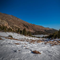
Our pre-meditated turn-around time was 11AM due to building storms and we left Fifth Lake just in time, snow was starting to fall heavily at 10:30AM. We retraced our steps quickly down to Fourth Lake, and soon found ourselves past Spirit Lake and at the tail end of Lake Verna. The downed trees, though still problematic, were superior to the long jaunt around Lake Verna. The trees made eerie creaking noises under the battering wind and we hustled to get back to East Meadow. The rocks scattered throughout the trail began to get slippery beneath the falling snow.
We spotted a couple across Spirit Lake on our ascent, and our first encounter of other hikers was just above East Meadow. Regrettably, the cloud coverage and precipitation hindered our ability to see East Meadow and surrounding peaks in all their grandeur, but the snow accumulating on branches was stunning; it had been a while since we’ve hiked in the snow.
With 0.5 miles remaining, we made our last stop of the hike – Adams Falls (8,460 ft). A loop trail fitted with a rock staircase leads to a platform overlook with a railing. Adams Falls is a series of small waterfalls conjoined into one. The water makes an abrupt turn and continues downward, which cannot be seen from the viewing platform. Adams Falls was a picturesque end to our day, enjoyable despite our aching legs.
Our hike to Fifth Lake is our longest to date: 19.6 miles round trip with roughly 3,000 feet of elevation gain, a 10 hour excursion. Many of the lake hikes near Grand Lake boast similar statistics, I anxiously await a return trip to the trails along the North Inlet.
Leave a Reply
You must be logged in to post a comment.